Ten Things to Know About Urban Vs. Rural
Is America becoming more urban? What portion of the population is now living in an urban (vs. rural) setting? Do we have a way of defining and measuring where and to what extent urban sprawl is taking place? The answers to all of these questions require that we have an agreed-upon definition of what it means to be "urban" or "rural".
This web page looks at the official Census Bureau definitions of urban and rural and identifies resources for determining how various geographic areas are classified as one or the other. We shall also look at how and where to get census and other data that can help us see the differences between the two area types (in terms of how many people, age distributions, income and poverty levels, etc.), and perhaps more importantly, what trends are related to them.
It may seem obvious that central cities are clearly urban, whereas most farms are clearly rural. But there is more and more development in places sometimes referred to as "exurbia" and in fringe areas located within or adjacent to smaller cities, where the urban/rural classification is much less obvious. Because the definition of this concept is so important, we feel obliged to keep trying to improve it. This is a good thing for having a better measure of what is going on recently, but it creates problems trying to analyze trends when the definition changes over time. The current definition of urban (which is also the definition of rural, since the two are complimentary) went into effect with the 2000 decennial census and is based upon population density data. Unless otherwise noted, all references to urban vs. rural in this document will be using this definition.
1. Urban vs. rural is assigned at the census block level.
Census blocks are the smallest geographic units that the Census Bureau recognizes in its geographic scheme. All other geographic areas used in census products can be defined as a collection of (usually, but not always, contiguous) census blocks.
Any other kind of geographic area — a city, county, school district, ZIP code, etc. — will not necessarily be classified as completely urban or rural. For example, Jackson county, MO is the core county of the Kansas City metropolitan area and would seem to be obviously an urban county. But according to the 2000 census, there were over 26,000 persons (4%) in Jackson county who were living in census blocks classified as rural. Even within the city limits of Kansas City, MO, 1.3% of the population was classified as living in a rural block. Looking at land area instead of population, 43.3% of the land area of the city of Kansas City is classified as rural! (Anyone who has had occasion to use the Kansas City airport, which is over 20 miles from downtown Kansas City and in a very rural setting but is within the city limits, will not be surprised by this statistic.)
2. There are no counties in Missouri that are 100% urban, except the independent city of St. Louis.
Of the 114 other counties in the state, only 33 are classified as being entirely rural.
3. 97.4% of the land area in the state of Missouri is classified as rural (per the 2000 Census).
But, only 30.6% of the population is classified as living in rural areas. Thus, almost 70% of the population of the state lives in about 2.6% of the land. Nationwide, the same 97.4% of the land area is classified as rural, but only about 21% of the population lives in these rural areas.
4. Geocorr can be used to see urban/rural breakdowns.
This application includes "urban-rural portion" as a choice on its source/target geography menus. Just select your state, select the geographic layer(s) of interest off the source geocode(s) menu and choose urban/rural from the target geocode(s) menu. Choose your weighting variable as either population (default) or land area. All of the statistics quoted above regarding portions of the population and land areas of various geographic entities were generated using Geocorr.
5. The short definition of urban and rural.
For Census 2010, the Census Bureau classifies as "urban" all territory, population, and housing units located within an urbanized area (UA) or an urban cluster (UC). It delineates UA and UC boundaries to encompass densely settled territory, which consists of:
- core census block groups or blocks that have a population density of at least 1,000 people per square mile and
- surrounding census blocks that have an overall density of at least 500 people per square mile.
In addition, under certain conditions, less densely settled territory may be part of each UA or UC.
The Census Bureau's classification of "rural" consists of all territory, population, and housing units located outside of UAs and UCs. The rural component contains both place and nonplace territory. Geographic entities, such as census tracts, counties, metropolitan areas, and the territory outside metropolitan areas, often are "split" between urban and rural territory, and the population and housing units they contain often are partly classified as urban and partly classified as rural.
6. Urban is sometimes confused with "metropolitan".
Or, more recently, "micropolitan", which is just metropolitan on a smaller scale. But the two concepts are significantly different. metro and micro-politan areas comprise complete counties; counties on the outer fringes of metro areas ("exurbia") often have the majority of their land areas and significant portions of their populations classified as rural. The metropolitan concept has more to do with whether you live in an area where you are either within or have access to an urban center. By "having access", we mean you can commute to work there (this is the primary criteria to being included in a metro area), access local TV and radio stations, subscribe to local newspapers, etc.
Urban/rural does not much care about how far away from an urban center you are. It has much more to do with the density of the population in the immediate area around where you live. Although 30.6% of Missouri's population was classified as living in a rural area in the 2000 census, only about 14% lived outside of any metropolitan or micropolitan area (72.8% lived in metropolitan areas and 13.2% in micropolitan areas). The implication is that over 3/4 of the rural population is also metropolitan. Nationwide, only about 25% of the rural population (about 14.6 million persons) lives outside of a metro area. About 51% live in metropolitan statistical areas and 24% in micropolitan statistical areas.
There are websites (for example) where the defintion of rural is presented as outside of an MSA (metropolitan statistical area). Although some agencies may find it convenient to use such definitions, and although there may be some logic associated with these alternate definitions, it is important to know that these are not the official definitions, and their widespread use just contributes to the confusion. It does seem easier just to say "rural" instead of "non-metro". It may be okay until somebody wants to know how many people live in those "rural" areas
7. The previous defintion of urban used city limits instead of urban clusters.
While the details of how urbanized areas (UA) changed as part of the new urban/rural definition changes for 2000, the concept was pretty much the same. Instead of a requirement for a place (city) of 50,000 or more to form the core of a UA, we now have a more sophisticated way of identifying densely settled population clusters of 50,000 or more. For example, Jefferson City, MO did not qualify as an urbanized area in 1990, because the city had a population of just under 40,000. Under the new criteria, however, the area does qualify, because it takes into account not just the population living within the city limits, but rather the entire densely settled area that includes most of the city.
The more important change in the urban/rural defintion came in how areas outside of UAs were classified. The new geographic entity involved is called an urban cluster (UC). An urban cluster is defined using the same concept as a UA, except that the central population threshold is lowered from 50,000 to 10,000. For example, we have a Poplar Bluff (MO) micropolitan area, because that city and its immediate environs has a population over 10,000 (but less than 50,000). This central cluster area has nothing to do with city boundaries, and everything to do with dense population settlement. If you live on the outskirts of Poplar Bluff but are part of either the densely settled core or of the less densely settled adjacent area, then you are within the urban cluster — and hence classified as urban. It has nothing to do with whether or not you live within any city limit.
Under the old defintion, if you lived outside an urbanized area ("big city"), then you were classified as urban if and only if you lived within a place of 2,500 or more population. That definition used to work pretty well, when people more or less lived "in town" or out in the "open country". But not any more; people living in unincorporated areas adjacent to smaller towns (such as Poplar Bluff) are living in densely settled areas and should be classified as urban. On the other hand, if you live in a small town of 2,500 or more that does not meet the criteria of having a 10,000-person population cluster associated with it, then you are now classified as rural instead of urban under the new definition.
8. Accessing census data for urban/rural components.
The Census Bureau publishes decennial census and American Community Survey data for geographic components of large geographic areas (such as states, regions, and the nation). A geographic component is something such as the urban or rural portion of an area, or the portion within metropolitan statistical areas or urbanized areas, or within central cities of metropolitan areas, etc. For example, on summary file 3 for the 2000 census, there are geographic component summaries at the state level and even more such summaries at the nation and U.S. region levels. The MCDC has found that when these geographic component summaries are intermixed with complete-geographic-area summaries, they can sometimes be a nuisance and cause confusion. So, we separated out the geographic component summaries and created datasets named usgeocomps in both our sf32000 and sf32000x (standard extract) filetype directories. The codes for the urban and rural components (i.e., the values of the geocomp variable on the summary observations) are "01" and "43", respectively. So, to see summary data for the rural portion of Missouri, you would navigate to the sf32000x subdirectory and select the usgeocomps.sas7bdat file. Within Dexter, you would filter based on the value of State (=29) and GeoComp (=43).
You can also access summaries for such geographic components through data.census.gov. For example, if you choose the AFF data sets option and then choose the 2000 decennial census and summary file 3 and detailed tables with a geographic summary level of state or above, then after your output is displayed they provide a menu bar that lets you change your results. If you click on the options pull-down you are presented with a geographic components choice. Follow the menus and make your choices. It's really pretty easy to generate tables for urban and rural portions of states and the nation.
You can get all the other detailed tables — things such as income measures, poverty level tables, housing value mediams and distributions, propensity to live in mobile homes, etc. — all this broken down not just by urban and rural but also by various subcategories of urban and rural, such as "Urban - in urbanized area - not in a central place" (which is what you might think of as "suburban").
If all you are interested in is how many persons and/or households within an area are classified as being urban and rural, that can be readily accessed from tables on files such as SF3. In our standard extracts based on summary file 3 data (filetype sf32000x), we include the variables urban, rural, InUAs (living in urbanized areas), InUCs (living in urban clusters), OnFarms (persons living on farms), UrbanHUs (urban housing units), and RuralHUs. There are corresponding percent variables for each of these items. All of these items are derived from tables on summary file 3. The definitions can be viewed in the metadata files. The data can also be viewed within our standard SF3-based demographic profiles application.
Geographic component summaries on census summary files is not new. Such summaries have always been published by the Bureau, although the number of categories has increased. Urban and rural have always been the most important and widely accessed catgegories. Keep in mind, however, that the definitions have changed over time, so the data are not entirely comparable.
9. Urban and rural does not get updated in the ACS.
The American Community Survey provides us with summaries of larger geographic areas throughout the decade. You might expect to be able to get geographic component summary data that would allow us to find out how many people now live in urban vs. rural areas and what their characteristics are. You might especially think this because the Bureau does indeed publish geographic component summaries based on the ACS, and urban and rural are among the geographic component categories. How does the Bureau assign the urban vs. rural characteristic to the ACS survey records?
The answer is that they geocode the address of the survey respondent, attaching (among other things) the 2000 census block. Then they assign the urban/rural code to the household/person based upon the code assigned to that census block as of 2000. Why not use the urban/rural code assigned to that block based on 2005 data?
Because that data does not exist! See item 4 in our Ten Things to Know about the American Community Survey (2005 edition) page. The ACS is not about head counts; it is about characteristics of persons and households. In order to define a census block as being urban or rural, it would require having a complete set of current block population counts, which would then have to be used as input to the Bureau's very sophisticated GIS-based program that examines complex density patterns in order to make the category assignments.
So, how am I to interpret the 1,803,146 persons in "rural areas"? If this number is higher than the comparable figure from the 2000 census, does it mean that people are moving from urban to rural areas? If by "rural area" you mean an area that was classified as rural in 2000, based on 2000 data patterns, then the answer is probably yes. But this does not necessarily mean that we are abandoning urban settings to live in more rustic ones. What happens when people from urban areas move to areas that used to be rural but that are adjacent to urban areas, those areas are converted from rural to urban. It is just that we do not measure and recognize this conversion until after the next decennial census. Of course, it is always possible that in some areas it may have gone the other way — that some blocks formerly classified as urban have now become rural. But anyone who follows development patterns in the U.S. knows that this sort of change is almost unheard of, barring a natural or man-made disaster.
The bottom line on this point is that the figures for the rural portions of states and the nation that come from the ACS are probably counting too many people as being rural, with the correesponding under-counting of the urban portions. If you are studying urban sprawl and you want to use ACS data to look at how much land area has been converted from rural to urban as the result of sprawl, you should not be looking at the ACS geographic component summaries for urban vs. rural.
10. A picture of rural population in Missouri.
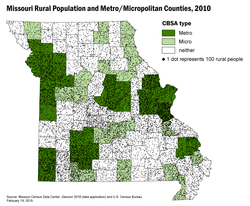
This map shows you what we were talking about in Item 6, above. Most of the rural population of Missouri (which is not at all an unusual state in terms of such things) lives in metropolitan or micropolitan areas. The figure we cited above that less than 3% of the land area of Missouri was classified as urban can be seen in this map. Although it does not display urban population explicitly, we know that it can only exist in an urbanized area or urban cluster. Urbanized areas/urban clusters and Metropolitan/micropolitan areas are very closely linked, with the UA/UC just being the densely settled core area of the metro/micro area. Urban territories on this map are green areas with no black dots. The St. Louis and Kansas City core areas are by far the largest such areas in Missouri. Most of the really dense clusters of black dots (rural population) are within the green areas, especially the dark green (Jefferson and Franklin counties just south and southwest of St. Louis, for example). The biggest cluster of dots in a non-metro-micro (white on the map) area is in the Lake of the Ozarks region — an area inhabited by early retirees and others seeking to get away from the big city. This area is only marginally classified as rural; with growth in the Osage Beach/Lake Ozark area this decade, it is very likely that soon we'll have a Lake of the Ozarks micropolitan area and urban cluster, which will result in a large portion of the area's population being reclassified as urban.
What many people think of when they think of a rural lifestyle is one where going "into town" involves a significant journey that may only happen maybe once a week or less. But that is really not the case with a great majority of the rural population now. If you are looking for that group, the better category would be persons living in the white areas of the map — i.e., outside any metro or micropolitan area. The majority of the rural population today (in Missouri, at least) may have septic tanks and may not have access to city utilities and other services, but they do live within an easy drive of some population center; the large majority, we suspect, have easy access to a Super Walmart. Most do not live on farms — only about 2.5% of Missouri's population lived on farms in 2000; that comes to about 1 of every 12 rural residents. Most live in areas that look very much like suburbs or in small towns like Hermann or Osage Beach.