MCDC News and Updates

Story Map

Manufacturing Employment in Missouri over the Past Decade


The manufacturing sector is the fifth largest employer in the United States and the third largest in Missouri (after health care and retail trade). This month, our partners at the Missouri Spatial Data Information Service (MSDIS) examine how manufacturing employment has changed in Missouri counties between 2011 and 2021 using County Business Patterns data from MCDC and the U.S. Census Bureau. These maps show us how important manufacturing is (and isn’t) in certain counties in Missouri.

Missouri Census Data Center frequently works with MSDIS on mapping and data projects. MSDIS is a spatial data retrieval and archival system offering many mapping resources, primarily focused on the state of Missouri.

Story Map

Missouri Unemployment Rates over Time

This month, our partners at the Missouri Spatial Data Information Service (MSDIS) present a swipe map showing changing patterns of unemployment in Missouri across two decades.

The left side of the swipe map shows unemployment rates by Missouri county for 2000, and the right side shows the rates for 2020. Clicking on any county will show basic employment and workforce stats for the selected county and year.

Missouri Census Data Center frequently works with MSDIS on mapping and data projects. MSDIS is a spatial data retrieval and archival system offering many mapping resources, primarily focused on the state of Missouri.

Story Map

Missouri Voter Turnout in General Elections Since 2000 (updated)

Our story map about Missouri voter turnout by county has been updated to include the November 2022 midterm election.

The Missouri Census Data Center frequently works with MSDIS on mapping and data projects. MSDIS is a spatial data retrieval and archival system offering many mapping resources, primarily focused on the state of Missouri.

Story Map

Missouri’s Changing Legislative Boundaries

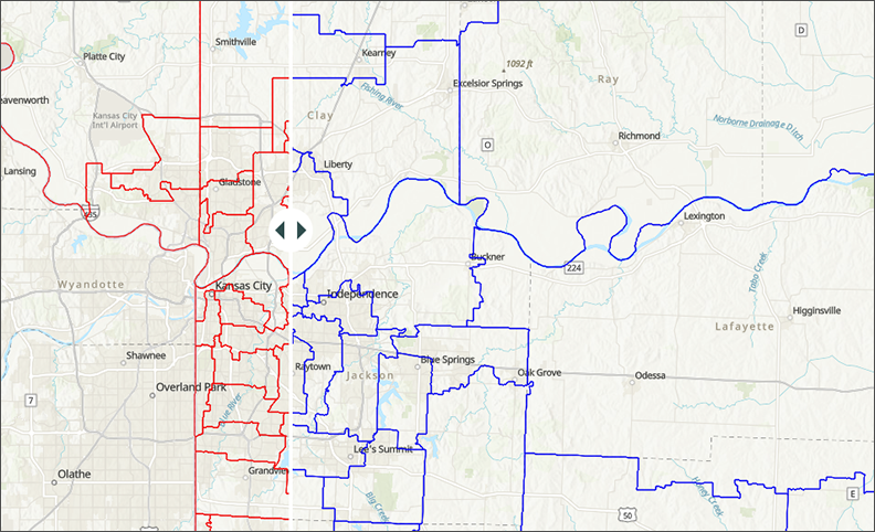
This month, our partners at the Missouri Spatial Data Information Service (MSDIS) present a set of “swipe maps” showing how the Missouri House and Senate district boundaries changed after the 2020 US Census.

The red outlines on each map (the left side of the swipe tool, in this case) indicate the new, post-2020 districts, and the blue outlines represent the previous boundaries. Clicking on any district will show the district number and, for the newer boundaries, the current office holder.

Missouri Census Data Center frequently works with MSDIS on mapping and data projects. MSDIS is a spatial data retrieval and archival system offering many mapping resources, primarily focused on the state of Missouri.

Story Map

Missouri Voter Turnout in General Elections Since 2000

How many people in Missouri actually exercise their right to vote?

As Missourians get ready to head back to the polls for the 2022 midterm election, our colleagues at the Missouri Spatial Data Information Service built a story map showing voter turnout for previous Missouri general elections from 2000 through 2020.

The Missouri Census Data Center frequently works with MSDIS on mapping and data projects. MSDIS is a spatial data retrieval and archival system offering many mapping resources, primarily focused on the state of Missouri.

Story Map

Change in Missouri Voter Turnout, 2000-2016

aerial view of downtown St. Louis

With this month’s MCDC/GRC story map, we explore the changes in voter turnout across the state between presidential elections to shed insight on how Missouri has gone from purple to bright red in just a few short years.

The map, designed by Jefferson Daubitz of the Missouri Spatial Data Information Service (MSDIS), examines the question of who votes, rather than who they vote for. It explores a variable too often ignored in politics — changes in turnout. Each map is fully interactive. Right-click on any county to open a small window that shows the change in voter turnout between each presidential election since 2000.

Missouri Census Data Center frequently works with MSDIS on mapping and data projects. MSDIS is a spatial data retrieval and archival system offering many mapping resources, primarily focused on the state of Missouri.

Story Map

Missouri Voter Turnout in General Elections Since 2000

How many people in Missouri actually exercise their right to vote?

As Missourians get ready to head back to the polls for the 2018 midterm election, our colleagues at the Missouri Spatial Data Information Service built a story map showing voter turnout for previous Missouri general elections from 2000 through 2016.

The Missouri Census Data Center frequently works with MSDIS on mapping and data projects. MSDIS is a spatial data retrieval and archival system offering many mapping resources, primarily focused on the state of Missouri.