MCDC News and Updates

Story Map

Missouri Voter Turnout in General Elections Since 2000 (updated)

Our story map about Missouri voter turnout by county has been updated to include the November 2022 midterm election.

The Missouri Census Data Center frequently works with MSDIS on mapping and data projects. MSDIS is a spatial data retrieval and archival system offering many mapping resources, primarily focused on the state of Missouri.

Story Map

Missouri Voter Turnout in General Elections Since 2000

How many people in Missouri actually exercise their right to vote?

As Missourians get ready to head back to the polls for the 2022 midterm election, our colleagues at the Missouri Spatial Data Information Service built a story map showing voter turnout for previous Missouri general elections from 2000 through 2020.

The Missouri Census Data Center frequently works with MSDIS on mapping and data projects. MSDIS is a spatial data retrieval and archival system offering many mapping resources, primarily focused on the state of Missouri.

Story Map

Change in Missouri Voter Turnout, 2000-2016

aerial view of downtown St. Louis

With this month’s MCDC/GRC story map, we explore the changes in voter turnout across the state between presidential elections to shed insight on how Missouri has gone from purple to bright red in just a few short years.

The map, designed by Jefferson Daubitz of the Missouri Spatial Data Information Service (MSDIS), examines the question of who votes, rather than who they vote for. It explores a variable too often ignored in politics — changes in turnout. Each map is fully interactive. Right-click on any county to open a small window that shows the change in voter turnout between each presidential election since 2000.

Missouri Census Data Center frequently works with MSDIS on mapping and data projects. MSDIS is a spatial data retrieval and archival system offering many mapping resources, primarily focused on the state of Missouri.

Story Map

Missouri Voter Turnout in General Elections Since 2000

How many people in Missouri actually exercise their right to vote?

As Missourians get ready to head back to the polls for the 2018 midterm election, our colleagues at the Missouri Spatial Data Information Service built a story map showing voter turnout for previous Missouri general elections from 2000 through 2016.

The Missouri Census Data Center frequently works with MSDIS on mapping and data projects. MSDIS is a spatial data retrieval and archival system offering many mapping resources, primarily focused on the state of Missouri.

Map of the Month

Missouri’s Registered Voters — Where Are They?

For the upcoming November 8 Election Day, this month we present a view of registered voters in Missouri.

Missouri registered voters in 2013

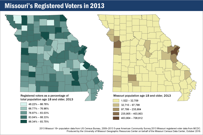
Looking at the map (left) of registered voters in 2013 as a percentage of total county population ages 18 and older, we see some interesting patterns. The areas around Kansas City and St. Louis represent two large blocks of registered voters, but that shouldn’t surprise anyone, because those places represent the two largest concentrations of people in the state. (The map on the right shows where Missourians aged 18 and older live.)

What about the rest of the state, though? Dade County stands out with a fairly high percentage of registered voters, but neither Boone nor Cole counties are in the top tier of voter registration. Then there are counties with lower total populations but higher registration rates: Carter, Chariton, Clark, Gentry, Reynolds, Shelby, Ste. Genevieve, and Worth are all in the highest tier of voter registration, despite not being highly populated.

What’s the point? In addition to the usual message of “every vote counts,” these two maps show that large populations do not necessarily translate to large voter populations. This will make for some interesting viewing once the returns start coming in on Election Day. Keep in mind, too, that this map of voter registration rates can be compared to a map of voter turnout to see whether these patterns remain the same. That’s a comparison for another month.